Blog
Photographer and history researcher Estelle Slegers Helsen explored the Lochaber area for four weeks in June this year to retrace the places where the Scottish photographer W.S. Thomson took his landscape pictures, both in black and white and in colour. The project, called Travel in Time (www.travelintime.uk) is supported by the West Highland Museum and the Year of Stories 2022 Community Fund. She keeps a travelog and here are her writings about the forth week on the road.
Travel in Time. Lochaber Series - Day 22. Saturday 11 June 2022
A blustery night with heavy rain. But I am still dry. I do not want the challenge the weather gods too much! Lots of rain and two visits to the End of the World. Due to the rain, it is a slow morning. I buy some breakfast at the Jetty Shop in Salen before heading to my first appointment, at 10 am near Salen, at the Camas Torsa car park, where I meet Liam. He has a possible clue where Thomson took his picture with a large fir tree, some leafless birches, and a view of Loch Sunart and Ben Resipol. Because we must wade through a sea of bracken in a beautiful part of the native forest along Loch Sunart, extra protection against thicks is necessary. I have already been bitten enough during this trip. The forest is magic, although it is not that old. While looking where Thomson stood in early spring, we chatted about different topics of the area and Liam’s view on the future. Travel in Time is also about the future of communities and landscapes. We wonder about half an hour in the area of the giant fir tree, which is supposed to be there even after 70 years, but it is the wrong three, so we hike down to our cars. I am delighted Liam took the time for this search because he hasn’t seen his family much in the past five weeks.
The weather is grey and dull, and rain comes and goes, so I decide to have some tea and cake at Cafe Tioram in Acharacle, where I also have lunch and stay for some hours for computer work. In the afternoon, I drive to Castle Tioram and see a rough high tide sea and many grey clouds. The small isle, where the castle, a ruin, is situated, is only accessible by low tide. But I am interested in how to get to places, up the rocks, behind Doirlin Cottage, for both pictures Thomson made of the castle at low tide. Rain starts pouring down again, and I can only conclude it will be a tough and challenging job to stand in Thomson’s footsteps. The only decent view I have is on Eileen Shona and Shona Beat, which is said to be the property of the Branson family, and both are only accessible by boat. I can also see Eileen an Fheidh, another smaller island; a large heap of rocks with some trees was up for sale more than a year ago. For some weeks, I played with the idea of buying the island, but I am happy I didn’t. This place is an excellent top candidate for the best spot at the End of the World.
But that is before I have seen Ardtoe, a small community about - a the crow flies - four miles to the west. Ardtoe, where Thomson took his most iconic pictures, lies east of the entrance of Kentra Bay. The photos, one taken at the end of the 1940s and the other mid-1950s, are taken from a high rock with a view of a few houses, the sandy beaches, the parties of smaller islands and rocks in the sea close by, and Rum and Eigg as a backdrop. The contrast between how I see this place for the first time (not from up the rocky hill, but at sea level) and when Thomson took his picture is the very opposite: Blue cloudy sky with a nice view of the isles, calm blue sea and croft land with some tiny houses, against a landscape soaked in the rain, with nearly no visibility, a grey almost fuming sea and a blustery wind. Both ways, my top candidate for the number one spot on the End of the World list. I once made a series for a Belgian Radio program on Sunday evening from the 1980s until 2001, titled The End of the World, a four-hour radio show with many forgotten stories, both factual and fictional. It was produced by Dree Peremans, who lived the last 20 years in France, where I regularly visited him and his wife, Greet. Dree died suddenly a few months ago, which was a shock for many people. Each time I reach the end of a road, what often happens during my adventures on the British Isles, I have to think about the radio programme and Dree. I now know what will be my challenge for tomorrow, weather permitting.
I drive back to Acharacle to prepare for the talk in the Community Centre, which ends in a slight disappointment because - I have my doubts writing this down - only one person attends the talk. So I give a one-on-one presentation. We have a good conversation, and after packing everything back in my car, I drive to the campsite for another night in the tent. The blustery wind calmed down, and the rain moved on. Just and the time and life…
Travel in Time. Lochaber Series - Day 23. Sunday 12 June 2022
People back home think I am a bit crazy, and that’s true. The making of the Travel in Time Lochaber series is, as expected, an adventure driven by things that happen or not while roaming around the area. I have learned you can prepare a lot, but you are always dependent on the cooperation of the local people, which is not bad. I am struck by the kindness and hospitality of the people I meet. Although the past days have been hard, because of the weather. I still reflect on the remakes of Thomson’s pictures, candid landscape photographs, wondering how close, or just not, my photos have to imitate Thomson’s work. Thomson knew the country well and could wait for some time, even several years, before visiting a location when the conditions were right - weather, light, season - a postcard-proof picture would be the final result. Foremost I search for the site where Thomson stood about 60 to 70 years ago. This has to be a match or a close match. Visiting the Fort William and wider Lochaber area for the fifth time also allowed me to make some remakes in October/November last year and in April of this year. The final result will not imitate Thomson regarding the time of the year and weather conditions. So, I don’t replicate his pictures. The framework has to be the same, his and my photos being visual cues to tell a story about the past, present and future of the pictures' places.
After breakfast in front of my tent, I packed my gear and went on the road, first for a scout near Strontian, a village known for its lead mines and the discovery of the metal strontium. Thomson visited the area in the late 1940s with a rather vague photograph of the lead mines, of which most were already closed. I quickly find the place from where the picture was taken and roam around the hill for a few hours without my tripod and camera equipment, unable to find the exact location. I recognise a series of features, but they never match the overall picture. I wonder if the road up in the hills got rerouted. I don’t think so. A talk tomorrow evening in the village church will probably shed light. The weather is pretty good with some bright spells but also a few flashes of rain. Also, a second picture taken near Strontian along the shore of Loch Sunart is a mystery. On my way to Salen, I stop a few times along the winding single-track road, but none of the short reckies unsolved the mystery of the place where the pictures (in colour and black and white) were taken. Arriving in Salen, I park at the Camas Torsa car park for another search for the large pine tree. I think I did find the tree, but a remake is impossible because of the overgrown birch and oak trees. The bracken is more than 5 feet high at this location, so I am a bit worried about thicks. I quit… a sensible decision. Back to the village of Salen, the weather is too grey for a remake of Thomson’s photo from near the jetty, so I decide to go to Acharacle. After a pitstop at the shop to stock supplies for the evening and the following morning, my next mission is the picture of Acharacle with a view of Loch Sunart and Ben Resipol. I find the hill where Thomson stood, near the new primary school, with a close match. Getting up that hill starts with a climb through brambles, and a close scrub of birch trees, not being there 70 years ago. Oh my… but there is Thomson's view on the village, the loch and the ben. Sunny spells come and go, just as showers are. Although I am not at the exact location taking my first remakes, clouds don’t cover the top of Ben Resipol. When I finally get close to where Thomson planted his tripod, the view still looks good, but clouds are dancing around the top of Ben Resipol. I make a series of remakes anyway because I probably won’t revisit this place in the next few days.
At 4 pm, I drive to Ardtoe. After chatting with a few local people - there are not that talkative because I knock on their doors unannounced - I decide to go up the rocky and steep hill, which is more than an adventure. But, as a combination of knowledge from which angle both Ardtoe pictures are taken and having a bit of luck, I find the location. The view matches, which makes me happy, but the isles of Rum and Eigg are covered in grey clouds, and only the outlines of the islands are visible. I see a band of rain coming my way from the sea but stay put, hoping it will be better in half an hour. I make a series of remakes from both locations nearly 30 feet apart from the same rock, now overgrown by moss, heather and bracken and only go down again when it is almost 7 pm. Driving back to the campsite, with a pitstop near Resipol, to phone the home front, Loch Sunart is bathing in flashes of the evening sun. With some midges dancing around my head, I have late dinner, write a late report of Saturday’s adventures and go to bed.
Travel in Time. Lochaber Series - Day 24. Monday 13 June 2022
When checking the weather forecast, I use several apps on my phone: the Met Office to have a first idea, XCWeather for an in-depth view and Clear Outside to focus on the clouds and the sky's visibility. All three agree that clouds will be the theme of the day. Clear Outside - always look at the bright side of life! - gives me some worries because low, mid and high clouds are predicted for 100% during all day. I poke my head outside the tent and notice the top parts of the hills surrounding Strontian are covered in mist. I make breakfast, hum a song of Monty Phyton - guess which song! - and enjoy a cup of coffee, oat flakes and milk, a banana with yoghurt, and some bread.
On the road, I follow the curves leading to the lead mines. Still, after a few miles, it is obvious it is no use, and I decide to turn around and visit the Ariundle Centre, recommended by one of the locals I talked to on my earlier visit in April. I settle at the centre, which offers a mix of self-catering facilities, a shop with eco-friendly and local nice-to-haves and a cafe/restaurant. I write, sort out pictures, contact people to visit when heading to Mallaig and catch up with emails and other computer stuff. Regularly I look outside to have a view of the hills that stay covered in clouds, starting to get troubled about the timing for the next few days and, foremost, the prospect of shooting the remakes. I have some cake and a lovely apple juice, order broccoli soup and have afternoon tea. Because it is a Monday and the holidays didn’t start yet, some other customers come round, but it stays calm. Kate, an Irish lady who runs the place, is very friendly and busy, and when I say I am not in a hurry, she acknowledges that’s the spirit.
At 3 pm, I decided to have a good look outside again, driving back up the road to the mines. The clouds are still there, so I go down to the village to have another good look at Thomson’s other picture taken in Strontian from the shores of Loch Sunart. I talk to some locals about how to reach an old jetty, and I find out about a deserted track going down from the road. The minute I take my gear out of the car, it starts raining as a surplus, so I shelter in the car for about an hour. I whistle the tune of the day.
6 pm is the time I park my car along the road at the Village Church (Church of England) to prepare for the evening talk in the village. It is a Telford church, built in the 1830s, designed by the man who also designed the plan for the Caledonian Canal. The local Sunart Heritage Group would like to turn the church with a plummeting number of church-goers into a multi-use centre also telling about the area's history. The main hurdles are the enormous cost of fixing the roof (Ballachulish slate) and getting the place ready for the 21st century. Probably nobody will be surprised that I love these kinds of places. The audience is all women except one man, Alistair, with who I talked in April. Being in bad health but still with vivid bright eyes, I was honoured he came up for the talk. After the presentation, he said with a big smile, he felt like the rooster in the hen house, although there was not much clucking. During the talk, a mystery was solved. I was utterly wrong about the area where I wandered around for three hours the day before because Thomson’s picture of the lead mines was taken much higher in the hills.
I went to the campsite, where some midges tried to join me in the tent, but I managed to keep most of them out. After contacting the home front, I tucked myself into the sleeping bag for the night.
Travel in Time. Lochaber Series - Day 25. Tuesday 14 June 2022
Time to move on, although I have made no remakes the past two days due to the weather. Today doesn’t look different from yesterday. I pack my tent in the rain, and it is the first morning midges attempt to be an annoyance. Both don’t bother me. I decide to have a full-cooked breakfast at Sunart Cafe, which only opens at 9.30 am, a place that throws you back in time with also 1980s music. I love these kinds of places. The breakfast is tasteful, and I stay longer to get some computer work done, leaving Strontian around noon to drive north to Mallaig.
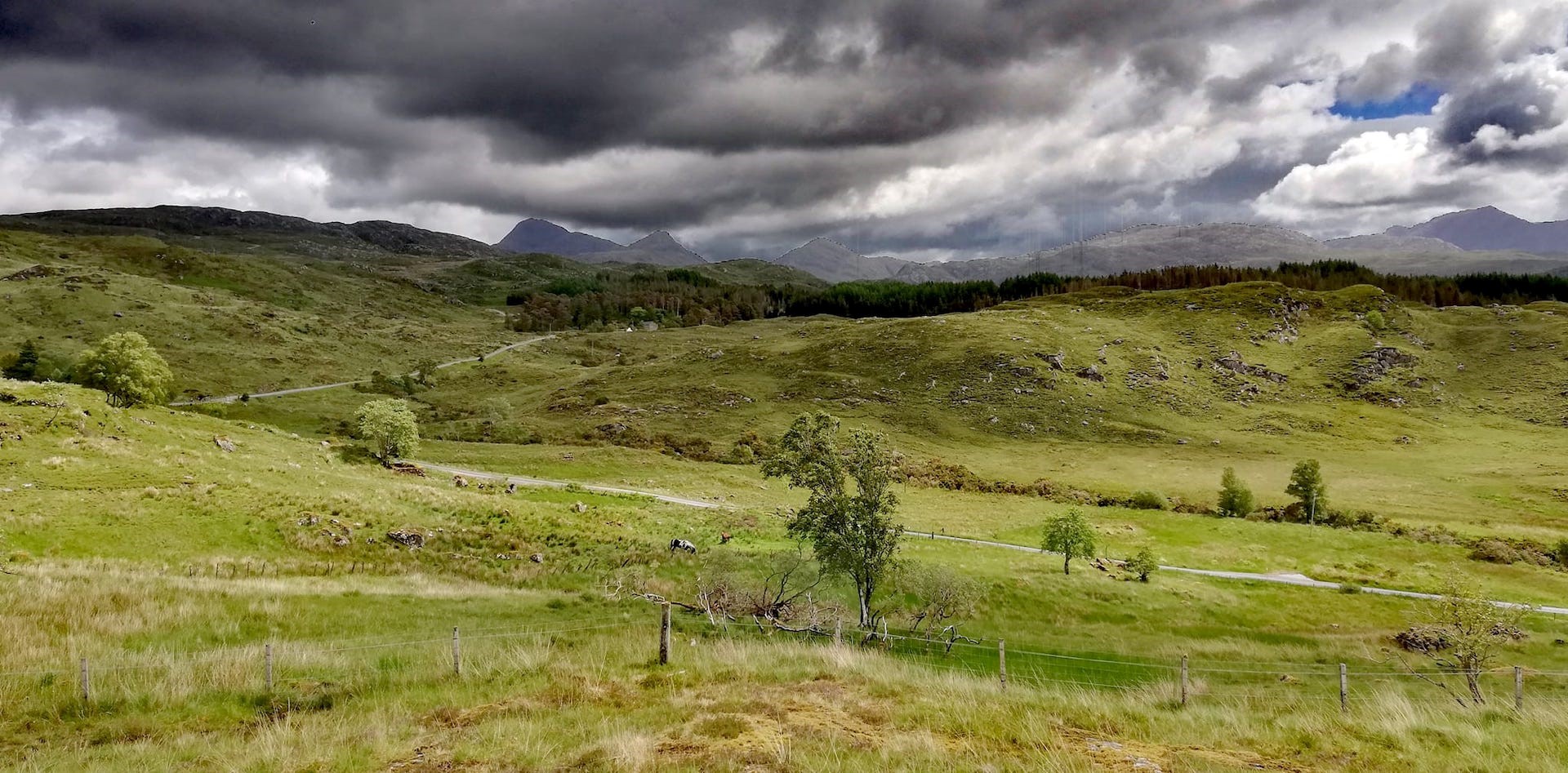
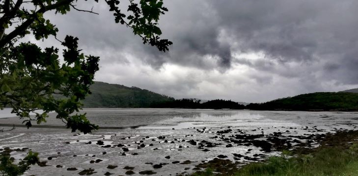
Grey and rainy skies are my partners during the drive, taking a few breaks to get a good look at the wild rigid and tree-covered Moidart landscape. It is one of the most deserted places in the area. Only Knoydart north east of Mallaig is more remote because you can’t go there by car. In Glenuig, I park at the Ardshealach Smokehouse to buy some delicious smoked salmon as comfort food for a late lunch. It is low tide, and the rocky islands scattered along the shores of the Sound of Arisaig look uplifted from the water, some covered with a shiny green-brown band of seaweed at the base. Few of them have grass or scrub grown on them.
A few miles before reaching Lochailort, where the road joins the road to the isles, running from Glenfinnan to Mallaig, I see smoke in the distance. It is the steam train slowly moving towards Mallaig. I never catch it, but on my way, I see people hurrying back to their cars after taking snapshots of the train that regularly runs over smaller viaducts, not as big as the famous ‘Harry Potter’ viaduct in Glenfinnan. A slow-moving rental camper van keeps the traffic behind, but I am not in a hurry.
Reaching Arisaig, I have a brief look at Astley Hall, where my final evening talk of this trip is planned. And then drive a few miles further to Back of Keppoch, where I pitch my tent a short stroll away from the white sandy beaches and faintly Caribbean-like coloured seawater. In the distance, Eigg, Rum and Skye are covered in clouds. After pitching the tent, I give it some air to dry. I probably will stay here until Sunday. I take my time to relax and have a last look at the evening presentation leafing through the pictures I will show. This is the area I know not so good yet, so I am still unfamiliar with the names.
After buying some essential breakfast items at the local Arisaig shop, I go to Astley Hall, where Jane is already waiting to unlock the doors. While putting everything in place, I talk about the area with her. The presentation went well. Some of the people are prepared to give an interview about what they recollect from seeing the Thomson photos, and I get additional referrals for older fishermen to go and talk to in Mallaig. Somewhat tired, I drive back to the campsite, chat with my husband at home and go to sleep while it starts raining… again.
Travel in Time. Lochaber Series - Day 26. Wednesday 15 June 2022
Back of Keppoch, like most other places I stayed during this travel, has a cuckoo, even two, at this End of the World. Both birds, accompanied by a series of other birds, and the tent clattering in the wind and hit by raindrops, create a morning stereophonic soundscape. It is breakfast time with a nice cup of fresh coffee, yoghurt, fruit, oat flakes and milk. This is to start the day that doesn’t look too bad.
In the morning, I drive to Morar, a few miles north, and talk to Pete and Sue, who did come and live in the village 20-odd years ago. Being fond of sailing, they visited the Scottish West Coast regularly, and because a world trip on a larger sailing boat was cancelled, they decided to move up north and ended up in Morar by accident. Although not ‘indigenous’, they know a lot about the area and can’t stop telling stories because they both emerged in the local history. Pete is interested in trains, particularly the Fort William to Mallaig railway line. They live next door to Morar Hotel, pictured in the backdrop of Thomson’s black and white picture of the white sands of Morar. I pinpointed the place when first visiting the area last April and, like the past days, hope for better weather for the remake.
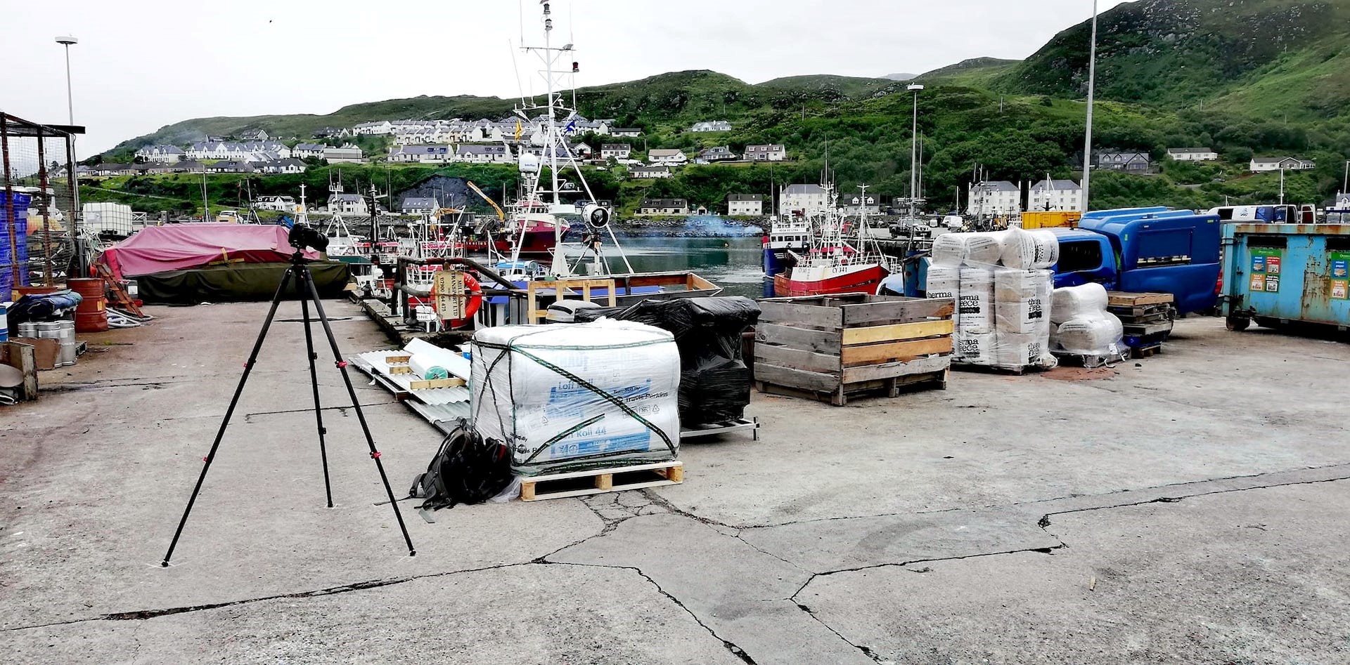
Then I got further up to Mallaig, where it is always a challenge to find space to park the car. Luckily the village is not that busy, and there are some available parking spots at East Bay, outside the harbour on the way to Mallaigveg. I want to speak to Pimmy MacClean, the Harbour Master, who I do find at his office overlooking the harbour from his first-floor office. He isn’t in, but his secretary gives him a call, and a few minutes later, his office desk is scattered with the prints of Thomson’s pictures of Mallaig. We start with an unusual Thomson photo about the night’s fish catch displayed near the fishing pier with about 20 locals pictured. Pointing his pencil to identify some of the people and starts talking about Mallaig being the most important herring port of Scotland in the past. Mallaig is a harbour with a CalMac ferry to the Isles, a smaller company bringing people and goods to and from Knoydart (there is no road), about five commercial fishing boats and, of course, The Jacobite steam train running twice a day during the holiday season. The ‘Harry Potter’ tourists are easily spotted, enjoying ice cream and going in and out of the local souvenir shops. Surprisingly Mallaig in the past was only a price with four crofts. It took Pimmy five seconds to identify where Thomson took the harbour picture, pointing to the place from his office windows.
After the interview, I fetch my tripod from the car, and because the weather wasn’t that bad and the hills as a backdrop at East Bay are visible, I give it a try. I have been warned some goods - shipped to or from the isles and Knoydart - could block the view. I ask a lift truck driver to move an empty crate to unveil the view. Where the fish was displayed and sold in the past, now broken goods and a seriously damaged dark blue car are waiting to be taken away. With a bit of sunshine, this picture will be even better, but it is what it is… I am happy with the result.
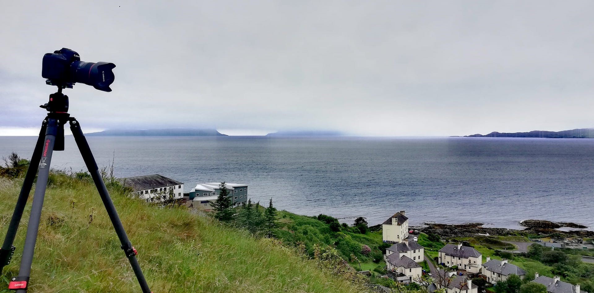
When I am back in the car, rain arrives, and grey clouds mystify the landscape. Looking from higher up the village Mallaig, with a view north of the harbour, where Thomson also took two photos, Knoydart, Skye, Rum and Eigg have vanished in the rainy mist. Exploring other places is not much of use because the skyline is a significant help in identifying the locations. I buy some food in the local Arisaig shop and finish my day at the campsite, cooking dinner, doing some writing and handling my emails. Somewhat worried about the rain, and much more is to come tomorrow night. The forecast is good for Friday afternoon, Saturday and also Sunday.
Travel in Time. Lochaber Series - Day 27. Thursday 16 June 2022
Going with the flow is the theme for the day, just as not to get annoyed by the weather. The latter you can’t change; just observe. The flow you can influence by taking decisions. After breakfast and some writing, I drive to the Land, Sea and Island Centre in Arisaig, a small welcoming museum and heritage centre on all the aspects of life and history of Arisaig and southwest Rhu Peninsula. I talk to one of the volunteers, telling her I am on a mission. She already got word. She advises me to come back in the afternoon to talk to one of the other volunteers.
A bit later, as expected, I drive to Mallaig by the old road, now the alternative coastal road, B8008, to go and find some of the ‘older’ local fishermen. I am too late to catch them at the pier, so I go to An Cala, a local tearoom, where they meet after their stroll along the Mallaig piers. I scan the place and immediately have an idea to which table I have to go and ask for Xander and Donny, two names I got from the harbour master Jimmy the day before. First, they give me a slightly suspicious look, but when explaining why I am here, they offer me a seat. We start talking, showing some of the Thomson pictures. A lot of chitchats, but we also identify some of the people in the photograph taken in the morning when displaying the night’s catch, all line fishing, I am told. They also recollect the names of the people who lived in the houses in the back of the picture, originally croft houses. After the Second World War, the flats in the picture were built. Some American tourists on a trip to Mallaig from Glasgow try to follow the conversation. I stay longer in An Cala for a coffee and an unhealthy rocky road sugar boast.
Because there is no rain and the view from Mallaig north and west on Knoydart and Skye is reasonably good, I search for the place on a hill where Thomson took a picture overviewing the village. I aim for a communication mast that can reach a very steep road. Yes, it is the view that Thomson saw 70 years ago. Although grey, I find the spot and take a series of remakes, with and without filters. When ready, rain is coming, and the forecast says it is not going to improve at all, on the contrary.
From Mallaig, I drive back to Arisaig for a second visit to the Land, Sea and Island Centre. Talking to the afternoon volunteer, she explains her husband is on duty Friday afternoon. I wander through the small museum looking for information about the area in the 1940s and 1950s. There is nothing much in the museum, but they also have an information section where I browse through most of the files and books. Some postcards give no reference to Thomson, but I find some interesting papers on the West Highland Railway Company that built the “road to the isles” railway line.
After buying some essentials for dinner and breakfast, I scout a Thomson picture taken at the Back of Keppoch with a view over the lower croft, now mostly campsite grounds, and of Skye. I try a few places and conclude the photograph was taken from a small hill north of Moss of Keppoch, near Back of Keppoch. Knowing where to be in the next few days is no use in going now because it starts raining. I go to the campsite to cook dinner and prepare for a rough night in the tent with a forecast of lots of rain and 30 mph winds, with gusts up to 50 mph. I survived, and you will read about this tomorrow…
Travel in Time. Lochaber Series - Day 28. Friday 17 June 2022
My goodness, what a terrible night of heavy rain and blustery winds. Although I make it through the night, I don’t catch much sleep. Most importantly, the tent is still dry and today’s forecast is promising. One of the campsite neighbours is less fortunate because their tent is collapsed, and they had to flee in their car. When I see them pitching their tent, I have a funny feeling it was one of their first nights in a tent, struggling for more than half an hour to have their accommodation ready, no help needed.
No use in looking back, I make a plan for the day, knowing the weather will be better from late afternoon and I have a meeting at 4.30 pm in Bracara, along the shores of Loch Morar. After breakfast, writing, computer work and checking emails, I prepare my gear for the day. Thomson's pictures on the Back of Keppoch area keep me busy. I first look for the lady who was at last Tuesday’s talk and can help me identify the features in Thomson’s pictures. I meet Ann, 92, in her house in Moss of Keppoch. “At last, you are here,” she said when knocking on her door. We chat for nearly an hour, sitting close to the fire because it still is chilly for the time of the year. Her magnifying glass ready, she scans one of the photos taken from above her house, although her home is not visible. When we say goodbye, the sun starts to get out, although many low clouds to the west and north spoil the view on the isles of Rum and Eigg and Skye. I retrace where Thomson took the picture with a view on the north part of Back of Keppoch.
Early afternoon I meet Henrik at the Land, Sea and Island Centre, where a bus of young American geologists is nearly leaving. “A most interesting area for geologists,” Henrik says to one of the last to hop on the bus they are touring. We talk about the Arisaig area. Although not a local, he is one of these ‘blowinns’ who did come and live in the area from other parts of Scotland, the rest of Britain and even overseas and immersed themselves in the local history. He is primarily interested in the SOE, Special Operations Executive, where people, not only from Britain but from all over the occupied continent, get training to conduct espionage, sabotage and reconnaissance in occupied Europa and support the local resistance. Some of the features in Thomson's pictures can be used to tell a part of this story.
On my way to Bracara, I make a pitstop on the opposite side of the banks where the River Morar hits the sea, known for its white beaches. I was here in April preparing for this adventure, and I realise I was at the wrong spot then for the remake of Thomson’s picture of the White Sands of Morar and Morar Hotel in the back against the hills. The place where I plant my tripod is much closer and probably the right spot. Once set, I wait for the right moment, clouds and sun playing a much-changing game of who is the boss, the light changing every second. Interesting… Bracara is again one of these End of the World communities where the road along the north shore of Loch Morar stops. It is possible to hike further to Tarbet at Loch Nevis. In Bracara, I meet Malcolm, the curator of the Mallaig Heritage Centre. He lives in one of the houses. There are just a dozen of them. Born in the village, we explore the steep hills to find Thomson’s spot where he took his picture with a breathtaking view to the east. There is no definite path, and the hill is covered in bracken and sheep muck. Finding the place, I set up my camera, and when all is in place, we wait for the light while talking about the history of Bracara and Malcolm’s life. Although the sun is still struggling, clouds are breaking up, but the hills on the south side of Loch Morar stay covered in a haze. The way down is more straightforward.
Then back to Mallaig for a reshoot of the harbour picture, with the late afternoon light perfectly hitting the scene. There are more fishing boats at the piers, partly blocking the main view, but this is the picture of Mallaig’s fishing harbour in 2022. I have Fish and Chips at Jaffys at the railway station, a much-visited place by the locals and then drive back along the old coastal road to the campsite. The islands and Skye are still covered in low clouds, and it will be like that the whole evening. I look for a place along the rocky and sandy shore at the campsite for some long-exposure photography experiments.
#travelintime #wsthomson #lochaberseries #westhighlandmuseum #YS2022

